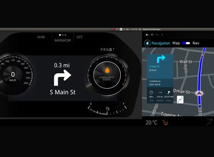


Navigation & Mapping
Navigating the World Around You
With more than a decade of experience in automotive mapping, we deliver products to major wireless carriers and enterprise customers, enabling the rapid deployment of mapping, directional, and other location-based services—utilizing our patented technologies.
Our navigation and mapping solutions deliver a robust platform for automotive product and the evolving Connected Car environment. We provide automatic map updates, real-time traffic, and integrated content. Our white label solutions allow OEMs, tier 1 suppliers, and telematics service providers to offer a customized experience integrated with their technology partners, while retaining control over safety and security.
- Features
Navigation platform provides a complete turn-key solution that's built upon a highly-reliable data center infrastructure.
- Animated DopplerNav™ weather overlay displays real-time weather conditions on the map. Users may access accurate weather conditions while traveling, increasing safety.
- Enriched 3D maps deliver a seamless experience with pan, zoom and tilt controls, 3D landmarks and buildings, highway signs, speed limit information with alerts, real-time traffic details and more.
- Spoken guidance is provided in a conversational tone to ensure users understand upcoming directions. Local and native language support allows the user to choose from more than 30 languages.
- Natural Lane guidance shows the precise traffic lane drivers should use, helping to avoid confusion and missed turns.
- Enhanced search supports intelligent search, auto-suggest and premium content such as gas prices, movie listings, local events, ratings and reviews.
- Point of interest (POI) database of over 24 million POI’s with information including detailed content such as pictures, hours of operation, contact information and other relevant details.
- Sharing of information is supported through messaging, email and social applications such as Facebook and Twitter.
- Search while navigating allows the user to conduct POI searches during a navigation session to locate gas stations, restaurants and other destinations along the route.
- Public transit, driving, and walking directions
- Display support ranging from no display to radio display, to full integration with factory-installed navigation
- On-board maps, off-board maps, or a hybrid of both
- Integrated or mobile device-based connectivity
